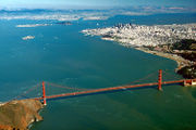
San Francisco Bay
| San Francisco Bay | |
|---|---|
 |
|
| River sources | Sacramento River San Joaquin River |
| Ocean/sea sources | Pacific Ocean |
| Countries | United States |
| Max. length | 60 mi (97 km) |
| Max. width | 12 mi (19 km) |
| Surface area | 400 to 1,600 sq mi (1,000 to 4,100 km2) |
| Settlements | San Francisco Oakland San Jose |
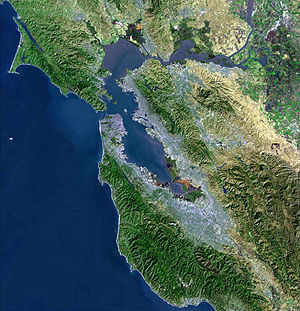
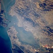
San Francisco Bay is a shallow, productive estuary through which water draining from approximately forty percent of California, flowing in the Sacramento and San Joaquin rivers from the Sierra Nevada mountains, enters the Pacific Ocean. Technically, both rivers flow into Suisun Bay, which flows through the Carquinez Strait to meet with the Napa River at the entrance to San Pablo Bay, which connects at its south end to San Francisco Bay, although the entire group of interconnected bays is often referred to as “San Francisco Bay”.
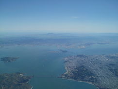
San Francisco Bay is located in the U.S. state of California, surrounded by a contiguous region known as the San Francisco Bay Area, dominated by the large cities San Francisco, Oakland, and San Jose.
Contents |
Size
The Bay covers somewhere between 400 and 1,600 square miles (1,040 to 4,160 square kilometers), depending on which sub-bays (such as San Pablo Bay), estuaries, wetlands, and so on are included in the measurement.[1][2] The main part of the Bay measures 3 to 12 miles (5 to 20 km) wide east-to-west and somewhere between 48 miles (77 km)1 and 60 miles (97 km)2 north-to-south.
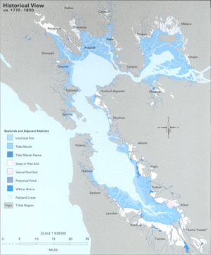
The bay was navigable as far south as San Jose until the 1850s, when hydraulic mining released massive amounts of sediment from the rivers that settled in those parts of the bay that had little or no current. Later, wetlands and inlets were deliberately filled in, reducing the Bay's size since the mid-1800s by as much as one third. Recently, large areas of wetlands have been restored, further confusing the issue of the Bay's size. Despite its value as a waterway and harbor, many thousands of acres of marshy wetlands forming the edges of the bay were considered for many years to be wasted space. As a result, soil excavated for building projects or dredged from channels was often dumped onto the wetlands and other parts of the bay as landfill.
From the mid-1800s through the late 1900s, more than a third of the original bay was filled and often built on. The deep, damp soil in these areas is subject to liquefaction during earthquakes, and most of the major damage close to the Bay in the Loma Prieta earthquake of 1989 occurred to structures on these areas.
The Marina District of San Francisco, hard hit by the 1989 earthquake, was built on fill that had been placed there for the Panama-Pacific International Exposition (1915), although liquefaction did not occur on a large scale. In the 1990s, San Francisco International Airport proposed filling in hundreds more acres to extend its overcrowded international runways in exchange for purchasing other parts of the bay and converting them back to wetlands. The idea was, and remains, controversial. (For further details, see the "Bay Fill and Depth Profile" section.)
There are four large islands in San Francisco Bay. Isolated in the center of the Bay is Alcatraz, the site of the famous federal penitentiary. Mountainous Yerba Buena Island is pierced by a tunnel linking the east and west spans of the San Francisco – Oakland Bay Bridge. Attached to the north is the artificial and flat Treasure Island, site of the 1939 Golden Gate International Exposition. Closest to shore, Angel Island was known as "Ellis Island West" because it served as the entry point for immigrants from East Asia. Raccoon Strait, between Tiburon and Angel Island, is the deepest part of the Bay. The federal prison on Alcatraz Island no longer functions, and the complex is now a popular tourist site.
Geology
San Francisco Bay is thought to represent a down-warping of the Earth's crust between the San Andreas Fault to the west and the Hayward Fault to the east, although the precise nature of this continues to be studied. During the last ice age, the basin now filled by the bay was a large linear valley with small hills, similar to most of the valleys of the Coast Ranges. The rivers of the Central Valley ran out to sea through a canyon that is now the Golden Gate. As the great ice sheets melted, sea level rose 300 feet over 4,000 years, and the valley filled with water from the Pacific, becoming a bay. The small hills became islands.
History
The first recorded European discovery of San Francisco Bay was on November 4, 1769 when Spanish explorer Gaspar de Portolà, unable to find the port of Monterey, California, continued north close to what is now Pacifica and reached the summit of the 1,200-foot (370 m) high Sweeney Ridge, where he sighted San Francisco Bay. Portola and his party did not realize what they had discovered, thinking they had arrived at a large arm of what is now called Drakes Bay. At the time, Drakes Bay went by the name Bahia de San Francisco and thus both bodies of water became associated with the name. Eventually, the larger, more important body of water fully appropriated the name San Francisco Bay.
The first European to enter the bay is believed to have been the Spanish explorer Juan de Ayala, who passed through the Golden Gate on August 5, 1775 in his ship the San Carlos, and moored in a bay of Angel Island now known as Ayala Cove.
This famous bay was the center of American settlement in the Far West during the 19th century. From the 1820s onward, American presidents and expansionists coveted the bay as a great natural harbor in the Pacific. After many failed efforts to buy the bay and varying areas around it, the US Navy and Army seized the region from Mexico during the Mexican-American War (1845–1848). On February 2, 1848 California was annexed to the U.S. with the signing of the Treaty of Guadalupe Hidalgo. A year and a half later, California requested to join the United States on December 3, 1849 and was accepted as the 31st State of the union on September 9, 1850. During the California gold rush of 1848-1850s, San Francisco Bay instantly became one of the world's greatest seaports, dominating shipping and transportation in the American West until the last years of the nineteenth century. The bay's regional importance became paramount when the transcontinental railroad reached its western terminus in Alameda on September 6, 1869.[3] The terminus was switched to the Oakland Long Wharf two months later on November 8, 1869.[4]
San Francisco Bay continues to support some of the densest industrial production and urban settlement in the United States. The San Francisco Bay Area is the American West's second-largest urban area with approximately 8 million residents.
Ecology
Despite its urban and industrial character, San Francisco Bay and the Sacramento-San Joaquin Delta remain perhaps California's most important ecological habitats. California's Dungeness crab, California halibut, and Pacific salmon fisheries rely on the bay as a nursery. The few remaining salt marshes now represent most of California's remaining salt marsh, supporting a number of endangered species and providing key ecosystem services such as filtering pollutants and sediments from the rivers.
Most famously, the bay is a key link in the Pacific Flyway. Millions of waterfowl annually use the bay shallows as a refuge. Two endangered species of birds are found here: the California least tern and the California clapper rail. Exposed bay muds provide important feeding areas for shorebirds, but underlying layers of bay mud pose geological hazards for structures near many parts of the bay perimeter. San Francisco Bay provided the nation's first wildlife refuge, Oakland's artificial Lake Merritt, constructed in the 1860s, and America's first urban National Wildlife Refuge, the Don Edwards San Francisco Bay National Wildlife Refuge (SFBNWR) in 1972. The Bay is also plagued by non-native species.
Salt produced from San Francisco Bay is shipped throughout the Western United States to bakeries, canneries, fisheries, cheese makers and other food industries and used to de-ice winter highways, clean kidney dialysis machines, for animal nutrition, and in many industries.
Low-salinity salt ponds mirror the ecosystem of the bay, with fish and fish-eating birds in abundance. Mid-salinity ponds support dense populations of brine shrimp, which provide a rich food source for millions of shorebirds. Only salt-tolerant micro-algae survive in the high salinity ponds, and impart a deep red color to these ponds from the pigment within the algae protoplasm.
The seasonal range of water temperature in the Bay is from about 8 °C (46 °F) to about 23 °C (73 °F).
Humphrey the Whale entered San Francisco Bay twice on errant migrations, and was successfully rescued and redirected each time in the late 1980s and early 1990s. This occurred again with Dawn and Delta a mother and calf in 2007.
Industrial, mining, and other uses of mercury have resulted in a widespread distribution in the bay, with uptake in the bay's phytoplankton and contamination of its sportfish.[5] In November 2007, a ship named COSCO Busan collided with the San Francisco – Oakland Bay Bridge and spilled over 58,000 gallons of bunker fuel, creating the largest oil spill in the region since 1996.[6]
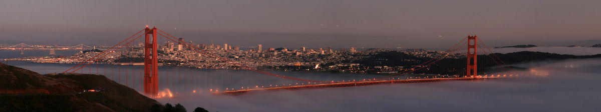
At times, San Francisco Bay is covered in a unique fog.
Bay fill and depth profile
San Francisco Bay's profile changed dramatically in the late nineteenth century and again with the initiation of dredging by the US Army Corps of Engineers in the twentieth century. Before about 1860, most bay shores (exception: rocky shores such as those in Carquinez Strait, along Marin shoreline, Point Richmond, Golden Gate area) contained extensive wetlands that graded nearly invisibly from freshwater wetlands to salt marsh and then tidal mudflat. A deep channel ran through the center of the bay, following the ancient drowned river valley.
In the 1860s and continuing into the early twentieth century, miners dumped staggering quantities of mud and gravel from hydraulic mining operations into the upper Sacramento and San Joaquin Rivers. GK Gilbert's estimates of debris total more than eight times the amount of rock and dirt moved during construction of the Panama Canal. This material flowed down the rivers, progressively eroding into finer and finer sediment, until it reached the bay system. Here some of it settled, eventually filling in Suisun Bay, San Pablo Bay, and San Francisco Bay, in decreasing order of severity.
By the end of the nineteenth century, these "slickens" had filled in much of the shallow bay flats, raising the entire bay profile. New marshes were created in some areas.
In the last years of the nineteenth and first decades of the twentieth century, at the behest of local political officials and following Congressional orders, the US Army Corps began dredging the Sacramento and San Joaquin Rivers and the deep channels of San Francisco Bay. This work has continued without interruption ever since, an enormous federal subsidy of San Francisco Bay shipping. Some of the dredge spoils were initially dumped in the bay shallows (including helping to create "Treasure Island" on the former shoals to the north of Yerba Buena Island) and used to raise an island in the Sacramento-San Joaquin Delta. The net effect of dredging has been to maintain a narrow deep channel - deeper perhaps than the original bay channel - through a much shallower bay. At the same time, most of the marsh areas have been filled or blocked off from the bay by dikes.
People tend to make mistakes thinking the Bay is a deep water due to the larger ships going in and out of the bay. The depth is as deep a a swimming pool, at least 12 to 15 feet deep and between Hayward, CA and San Mateo, CA going all the way to San Jose, CA is 12 to 36 inches deep. The deepest part of the bay is under and out of Golden Gate Bridge which is 300 feet. People question the large ship going in and out of the bay, there are underwater channels that ships have to be in and has to be dredge out to maintain a deep area.
Transportation
San Francisco Bay was traversed by watercraft since before the coming of Europeans; the indigenous peoples used their canoes to fish and clam along the shoreline. The era of sail brought ships that communicated with the rest of the world and served as early ferries and freighters within the Bay and between the Bay and inland ports such as Sacramento and Stockton. These were gradually replaced by steam-powered vessels starting in the late 19th century. Several shipyards were early established around the Bay, augmented during wartime. (See e.g. Kaiser Shipyards)
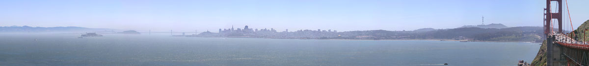
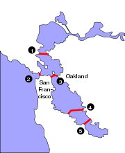
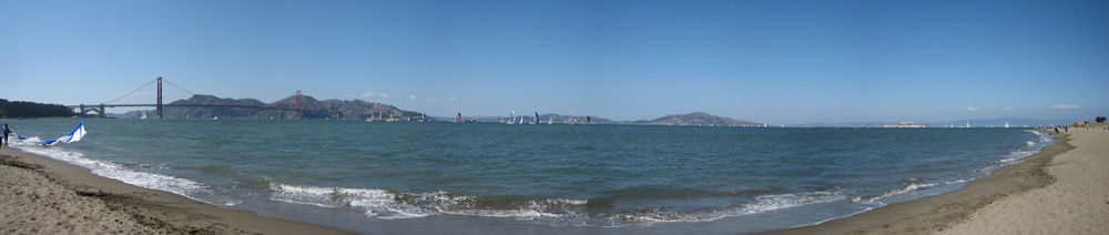
San Francisco Bay is spanned by six bridges, five of them dedicated to vehicle traffic: the Golden Gate Bridge (which was the largest single span suspension bridge ever built at the time of its construction), the Richmond-San Rafael Bridge, the San Francisco – Oakland Bay Bridge, the Hayward-San Mateo Bridge, and the Dumbarton Bridge. The sixth is the currently unused railroad bridge just south of the Dumbarton Bridge. The bay is also spanned by the Transbay Tube, an underwater tunnel through which BART runs. Prior to the construction of these infrastructures, transbay transportation was dominated by fleets of ferryboats operated by the Southern Pacific Railroad and the Key System transit company. However, in recent decades, ferries have returned, primarily serving commuters from Marin County, relieving the traffic bottleneck of the Golden Gate Bridge. (See article Ferries of San Francisco Bay).
The Bay also continues to serve as a major international shipping port, served by a large container facility operated by the Port of Oakland, and two smaller facilities in Richmond and San Francisco.
Recreation
San Francisco Bay is a mecca for sailors (boats, as well as windsurfing and kitesurfing), due to consistent strong westerly/northwesterly thermally-generated winds (Beaufort force 6 (15-25 knots) is common on summer afternoons) and protection from large open ocean swells. Yachting and yacht racing are popular pastimes and the San Francisco Bay Area is home to many of the world's top sailors.
Kite boarding and wind surfing are also popular in the bay.
Gallery
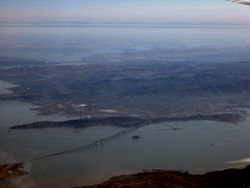
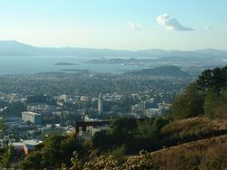 The City of Berkeley, the Bay and Marin County in the background as seen from the Claremont Canyon reserve |
 Mount Tamalpais view across San Pablo Bay at Point Pinole Regional Shoreline in Richmond |
 San Pablo Bay portion of San Francisco Bay at the Richmond-San Rafael Bridge |
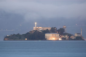 Alcatraz at dawn on San Francisco Bay |
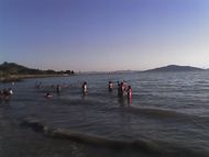 People also swim recreationally, at Kellar Beach in Richmond's Miller/Knox Regional Shoreline. |
 Oil Spill in the Bay |
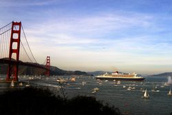 RMS Queen Mary 2 in San Francisco Bay |
See also
- Islands of San Francisco Bay
- Golden Gate
- Mount Tamalpais State Park
- Mount Diablo State Park
- Napa Sonoma Marsh
- Point Pinole Regional Shoreline, Richmond
- Eastshore State Park
- Hydrography of the San Francisco Bay Area
References
- ↑ Symphonies in Steel: San Francisco – Oakland Bay Bridge and the Golden Gate
- ↑ San Francisco Bay Watershed Database and Mapping Project
- ↑ Alta California, September 7, 1869
- ↑ http://cprr.org/Museum/Southern_Pacific_Bulletin/From_Trail_to_Rail_17.html cprr.org
- ↑ Conaway CH, Black FJ, Grieb TM, Roy S, Flegal AR (2008). "Mercury in the San Francisco Estuary". Rev Environ Contam Toxicol 194: 29–54. PMID 18069645.
- ↑ Oil oozes in S.F. Bay after ship hits bridge - Los Angeles Times
Further reading
- 1999 Grolier Multimedia Encyclopedia.
- 1988 Encyclopædia Britannica.
External links
- San Francisco Bay: Portrait of an Estuary, David Sanger and John Hart, University of California Press
- Barging In - A Short History of Liveaboards on the Bay
- Army Corps of Engineers Bay Model: Working scale model of the Bay
- BoatingSF.com: Photos of SF Bay and its boats, plus online cruising guide
- SF Estuary Institute: San Francisco Bay Historical View Maps
- Save San Francisco Bay: Protect and Restore San Francisco Bay
- sfbaywildlife.info Guide to San Francisco Bay wildlife
- Early History of the California Coast, a National Park Service Discover Our Shared Heritage Travel Itinerary
|
|||||||||||||||||||||||||